


 For Bangladesh, floods are not an occasional disaster but a recurring reality. Every year, as the monsoon arrives, rivers swell, low-lying areas disappear beneath water and millions of people begin another struggle against nature. This year, the Flood Forecasting and Warning Centre has once again warned that Bangladesh may experience flooding during July and August, particularly in the Brahmaputra and Meghna river basins. The warning is not an isolated prediction. It reflects a pattern that has defined the country’s geography and climate for centuries. Yet an important question remains: why does Bangladesh experience floods almost every year and can this recurring disaster be prevented?
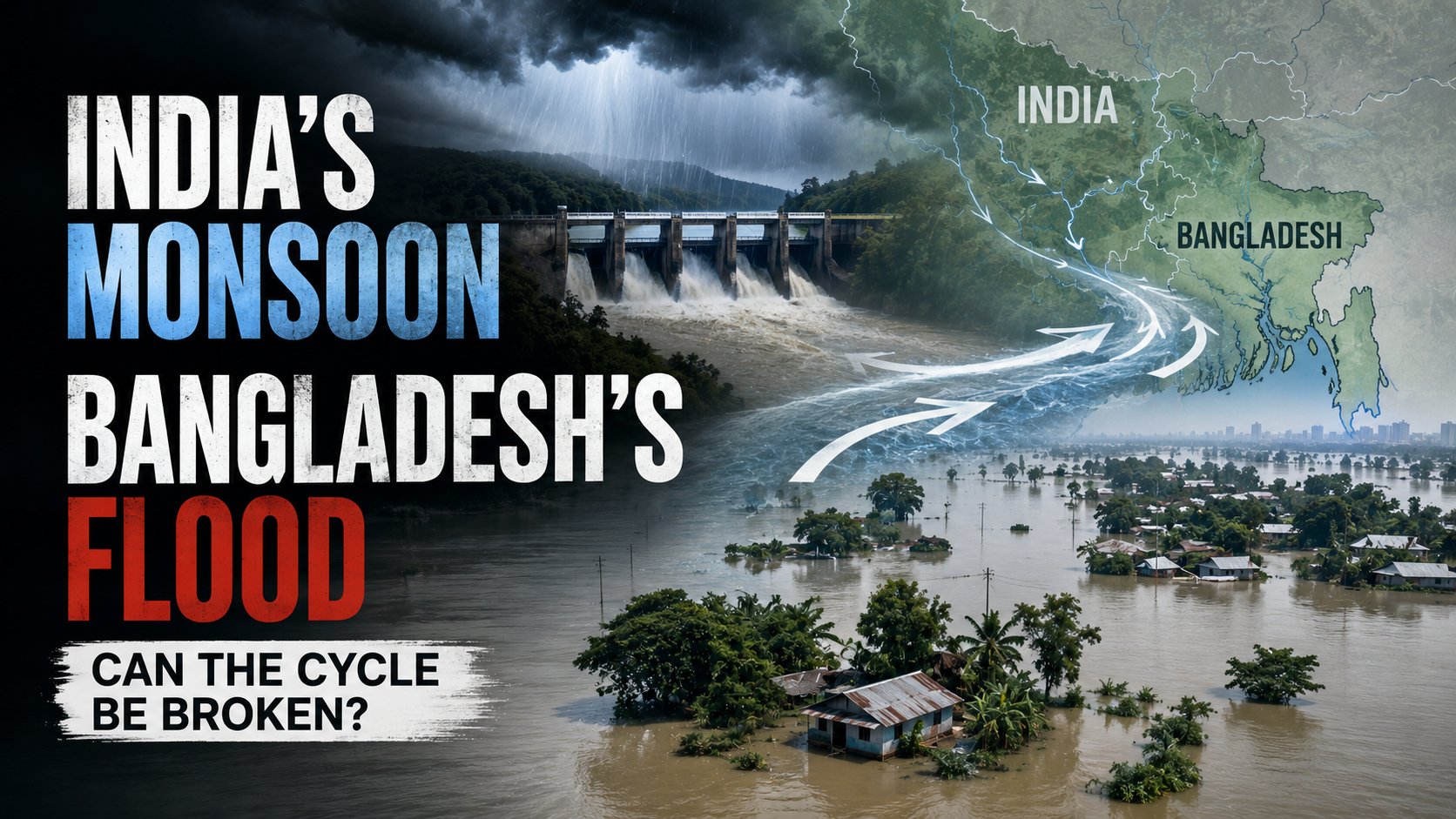
The answer begins with geography. Bangladesh is situated on the world’s largest delta where three mighty river systems—the Ganges, the Brahmaputra and the Meghna—converge before emptying into the Bay of Bengal. More than ninety percent of the water flowing through these rivers originates outside Bangladesh. Heavy rainfall in India, Nepal, Bhutan or China’s Himalayan regions eventually reaches Bangladesh regardless of the weather within the country. As millions of cubic metres of water flow downstream, rivers overflow and vast areas become inundated.
The monsoon further intensifies the situation. Between June and September Bangladesh receives the majority of its annual rainfall. When intense local rainfall combines with heavy precipitation in upstream catchment areas, rivers rise rapidly. If several major rivers reach their peak simultaneously, the result can be catastrophic flooding. History has repeatedly shown that Bangladesh suffers its worst floods when the Brahmaputra and Meghna carry peak flows at the same time.
Climate change has made this natural process increasingly unpredictable. Rising global temperatures have altered rainfall patterns across South Asia. Scientists are observing more intense cloudbursts, prolonged rainfall and sudden weather extremes. Himalayan glaciers are melting at faster rates while warmer air holds more moisture than before. These changes contribute to larger volumes of water entering river systems during the monsoon. Consequently floods that were once expected every few decades are becoming more frequent and more destructive.
Human activities have also amplified the crisis. Rivers and canals that once carried excess water have gradually become narrower because of encroachment, pollution and sediment accumulation. Wetlands that naturally stored floodwater have been filled to accommodate roads, factories and housing projects. In cities, inadequate drainage systems and unplanned urban expansion leave rainwater with nowhere to go. Even moderate rainfall now creates severe waterlogging in many urban centres.
Deforestation both inside and outside Bangladesh has further increased flood risks. Forests absorb rainwater and slow down runoff. When trees disappear, rainwater reaches rivers much faster while eroded soil raises riverbeds through sedimentation. As rivers lose depth, they can no longer carry the same volume of water. Overflow becomes inevitable.
Population pressure has made the consequences even more severe. Millions of people live along riverbanks because fertile floodplains support agriculture and fishing. Unfortunately these communities also become the first victims whenever rivers burst their banks. Homes collapse, crops disappear, livestock perish and transportation networks break down. Schools remain closed while healthcare services become difficult to access. Floods therefore create not only humanitarian crises but also long-term economic setbacks.
Can Bangladesh stop floods completely? The honest answer is no. Floods are an integral part of the country’s natural ecosystem. They replenish soil fertility, recharge wetlands and sustain biodiversity. Attempting to eliminate floods entirely would neither be practical nor environmentally desirable. The real challenge is reducing their destructive impact while learning to coexist with them.
The first priority should be strengthening river management. Regular dredging can restore river depth and improve water flow. Encroachment on rivers and canals must be stopped through strict enforcement of environmental laws. Restoring natural waterways would allow excess water to spread more safely instead of overwhelming populated areas.
Protecting wetlands is equally important. Floodplains act as natural reservoirs that temporarily store floodwater during periods of heavy rainfall. When these areas are converted into buildings or industrial zones, floodwater has nowhere to accumulate except residential neighbourhoods. Conserving wetlands is therefore not only an environmental responsibility but also an effective flood-control strategy.
Infrastructure planning must also adapt to changing climatic realities. Roads, bridges, embankments and drainage systems should be designed to withstand more intense rainfall and higher river levels. Urban planners need to ensure that cities have sufficient canals, retention ponds and open spaces to drain rainwater quickly. Flood-resistant housing should become a priority in vulnerable districts.
Technology can significantly improve preparedness. Bangladesh has already made remarkable progress in flood forecasting. Early warning systems now provide forecasts several days in advance. Expanding these systems through satellite monitoring, artificial intelligence and real-time hydrological data can further improve forecasting accuracy. However technology alone is not enough. Warnings must reach people quickly through mobile phones, community volunteers, local governments and the media so that families have enough time to move livestock, protect valuables and seek safe shelter.
Regional cooperation is another essential component. Since most river water originates outside Bangladesh, effective flood management requires close collaboration with neighbouring countries. Sharing real-time rainfall data, river discharge information and dam operations would help Bangladesh prepare more effectively for incoming floodwaters. Water diplomacy should therefore become an important part of regional cooperation.
Communities themselves also play a crucial role. Families living in flood-prone areas should keep emergency food, clean drinking water, essential medicines, flashlights and important documents ready during the monsoon season. Local disaster preparedness training can help residents respond calmly and efficiently during emergencies. Schools, mosques and community centres can serve as temporary shelters if they are properly equipped.
Agriculture must also become more resilient. Farmers can cultivate flood-tolerant crop varieties, adjust planting calendars and diversify income sources to reduce losses. Expanding crop insurance and financial assistance programmes would enable farming communities to recover more quickly after disasters.
Finally, climate adaptation must become a national priority. Bangladesh has earned international recognition for its disaster management achievements, particularly in reducing cyclone-related deaths. A similar long-term commitment is now needed for flood resilience. Investments in scientific research, sustainable infrastructure, environmental conservation and public awareness will determine how successfully the country faces increasingly uncertain climate conditions.
Floods may remain an unavoidable feature of Bangladesh’s landscape but widespread devastation does not have to be. Nature cannot always be controlled but human vulnerability can certainly be reduced. With sound policies, scientific planning, responsible environmental management and informed communities, Bangladesh can transform annual floods from recurring national crises into manageable natural events. The challenge is no longer whether floods will come. The challenge is whether the nation will be fully prepared when they do.
আপনার মতামত জানানঃ